

Affiliate Disclosure: This post contains affiliate links. If you buy through these links, we may earn a small commission at no extra cost to you. We only recommend gear that serves the hiker.
知其白,守其黑。
In the Dao De Jing, knowing the white while keeping to the black means you understand the bright, visible thing and still hold yourself to the quiet thing underneath it. For a hiker, the white is the technology: the device that knows where you are, the message it can send, the emergency button. The black is the terrain itself — the ground under your feet, the trail you are reading, the attention you bring to the land. A backcountry GPS device serves the hiker well when the hiker knows what it does and keeps the primary attention on the landscape. A device that demands constant looking at a screen does not serve that standard. It is not a safety net. It is a lens that replaces the hiker’s relationship with the land.
That idea is the standard this guide uses, and it comes from Beyond the Blue Dot — the guide that set the case for reading terrain with your senses first and a screen only when the trail is genuinely unclear. This guide applies that framework to the five devices that earn a place in the backcountry pack.
All specifications listed here are sourced from Amazon at the time of writing. Weights, battery life, display size, and other figures can vary by model year, and current pricing is listed directly on the Amazon product pages. Check the Amazon listing for the most up-to-date numbers before you buy.
The question is simple: does this device know its place?
The Five Devices
| Device | Best For |
|---|---|
| Garmin inReach Messenger | Day hikers who want the lightest possible check-in device with a simple interface |
| Garmin inReach Mini 2 | Solo and small-group hikers who need two-way messaging and SOS without a navigation screen |
| ACR ResQLink view | Solo hikers who want a no-subscription emergency beacon |
| Garmin Instinct 2 Solar | Day hikers who want GPS on the wrist without carrying a separate device |
| Garmin GPSMAP 66i | Multi-day travelers who need a navigation screen and satellite communication in one device |
The first four devices serve the hiker who walks. They are small. They do not require a screen to check in or to call for help. The last device serves the hiker who genuinely needs a navigation screen. It is heavier and more involved. Pick the device whose role matches how you move — and remember that the role of any backcountry GPS device here is insurance, not a replacement for paying attention.
1. Garmin inReach Messenger — The Simplest Check-In Device
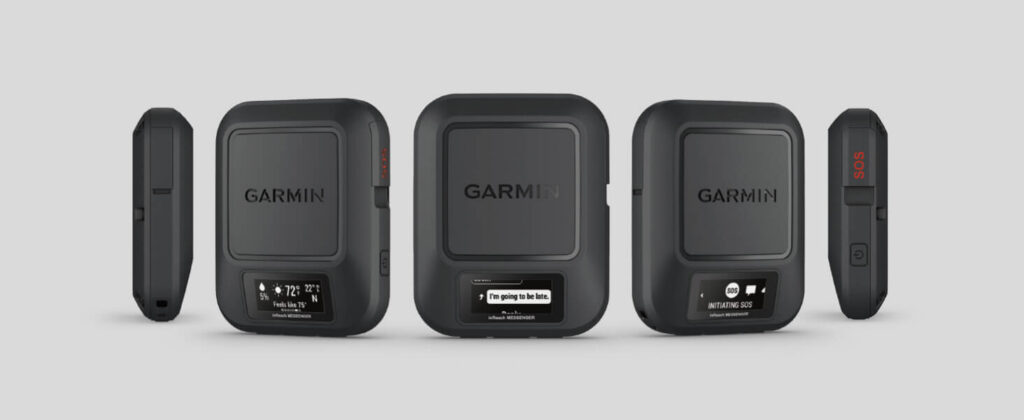
Weight: 4 oz | Battery life: up to 28 days standby | Connectivity: Iridium satellite network | Display: 1.1 in MIP monochrome, sunlight-readable | Supported GNSS: BeiDou, GPS, Galileo, QZSS | Best for: Day hikers who want the lightest check-in device with a simple interface | Worst for: Hikers who need weather forecasts, maps, or are inside cell coverage all day
The inReach Messenger is the lightest and simplest communication device on the Iridium list, and at 4 ounces it is light enough to clip to a pack strap, tuck in a hip belt pocket, or slip into a jacket pocket and forget. It has a small monochrome display — 160 × 68 pixels, sunlight-readable — just enough to confirm that a button press registered and a message sent. It is not a screen for reading maps. It is a confirmation screen, no more.
It does three things: send a check-in, call for help, and reply to a message. The hiker checks the device at the trailhead, sends a check-in from the summit, and is done. If the hiker is lost, pressing the SOS button brings a trained Garmin IERCC coordinator within minutes, 24/7. The Iridium network covers the globe, including the poles, and does not require a cell signal or a line of sight to one satellite.
The device supports four global satellite systems — BeiDou, GPS, Galileo, and QZSS — so position is reliable even in tight terrain. Check-in messages sent through the pre-set templates do not count toward the monthly text allotment, so the hiker who checks in daily is not burning through a subscription.
An active satellite subscription is required for messaging, SOS, and location sharing, and the cost is listed on the Garmin subscription page. The device earns its place by knowing it is a check-in tool and never trying to be a navigator.
Why it fits knowing the white and keeping to the black: it knows the white — its position, its message, its SOS — and keeps to the black by giving the hiker just enough information to confirm it worked and nothing more. The attention stays on the terrain.
2. Garmin inReach Mini 2 — The Two-Way Safety Net
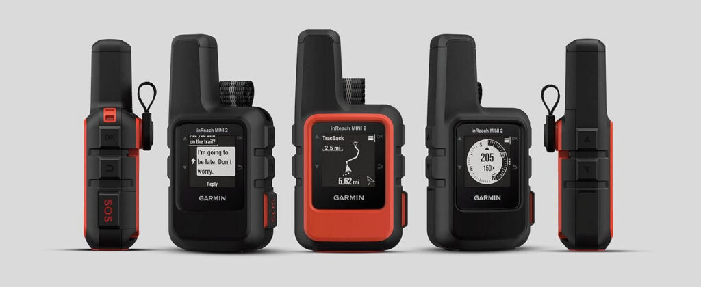
Weight: 3.5 oz | Battery life: up to 14 days in 10-minute tracking mode (336 hours) | Connectivity: Iridium, global | Features: Two-way messaging, SOS, Track and Share, weather, air-to-ground, TracBack routing, digital compass | Display: 1.27 in MIP monochrome, sunlight-readable | Water resistance: IPX7 | Best for: Solo and small-group hikers needing two-way messaging and SOS | Worst for: Hikers who will not pay a subscription fee
The inReach Mini 2 is the communicator most clearly designed to be a safety net beneath the hiker’s attention. It is not a primary navigation tool. It is a two-way messaging link, an SOS button, a way to check in with the people waiting at the trail end, and a digital compass that gives heading information even when the hiker is not moving.
The Iridium network covers the entire globe. A message sent from a valley, a dense forest, or a cave entrance is still delivered. Pressing the SOS button brings a trained coordinator within minutes. At 2.04 × 1.03 × 3.9 inches and 3.5 ounces it fits the way a small wallet fits — in a pocket, unnoticed. The IPX7 water resistance means rain and a submersion in shallow water do not end its usefulness.
The Mini 2 adds capabilities the Messenger does not have. TracBack routing draws the hiker’s exact path in reverse so they can navigate back to where they started without a map. A built-in digital compass gives accurate heading even when the hiker is standing still. The Garmin Explore app syncs with the device for trip planning and topographical mapping on a paired smartphone.
The battery, at 336 hours in 10-minute tracking mode, covers a full two weeks of checking in without a recharge. The GPS supports multiple global satellite systems, so position is reliable across the range of terrain a backcountry hiker encounters.
An active satellite subscription is required for messaging, SOS, and location sharing, and the cost is listed on the Garmin subscription page. The Mini 2 answers the quiet anxiety the hiker carries — not from any device, but from the knowledge that something could go wrong and there is no way to tell anyone.
Why it fits: it sits in the pack, sends a check-in, calls for help if something goes wrong, and never asks the hiker to look at a map. It is the white the hiker knows cold, and the black — the attention on the land — stays where it belongs.
3. ACR ResQLink view — The No-Subscription Beacon
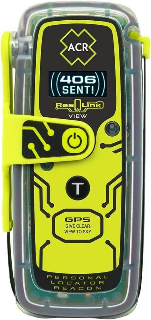
Weight: 5.28 oz | Battery life: up to 28 hours active | Connectivity: 406 MHz COSPAS-SARSAT (no subscription) | Display: 1 in OLED | GPS: built-in | Strobe: bright LED and infrared strobes | Best for: Solo hikers who want the most reliable no-subscription emergency beacon | Worst for: Hikers who need two-way messaging or check-ins
The ResQLink view is not a GPS device. It is a personal locator beacon, and it is the most reliable emergency beacon on this list because it uses the 406 MHz COSPAS-SARSAT network — a government-run global search-and-rescue system that does not require a subscription, a cell phone, or a separate communication device.
It has one button. Press it, and the beacon sends a distress signal with GPS position on the 406 MHz emergency distress frequency, paired with a 121.5 MHz homing signal. The signal is picked up by the three COSPAS-SARSAT satellite constellations and relayed directly to search-and-rescue agencies worldwide, without a rescue monitoring center in the chain. The bright LED strobe and the infrared strobe add visual signals that rescuers can see from the air and from the ground.
At 4.52 × 2.03 × 1.49 inches and 5.28 ounces it is rugged, buoyant, and designed to be carried — belt clips, attachment straps, and a lanyard come in the box. The OLED display confirms the status at a glance. The battery, at 28 hours of active transmission, gives the hiker time to be found.
The limitation is the same as the strength: it is one-way. No backcountry GPS device is one-way by design, but this one is a distress tool rather than a navigation tool — the hiker sends a distress signal and rescue agencies respond, but the hiker does not send a message, does not receive a message, and does not check in. The beacon is insurance, not a tool. If you want the most reliable way to call for help in a genuine emergency and do not want a monthly subscription, this is it.
Why it fits: it makes no sound in ordinary conditions, runs a small screen that only matters when the single moment arrives, and does nothing until that moment — then it does exactly one thing, end to end. That is knowing its place better than any screen can.
4. Garmin Instinct 2 Solar — GPS on the Wrist
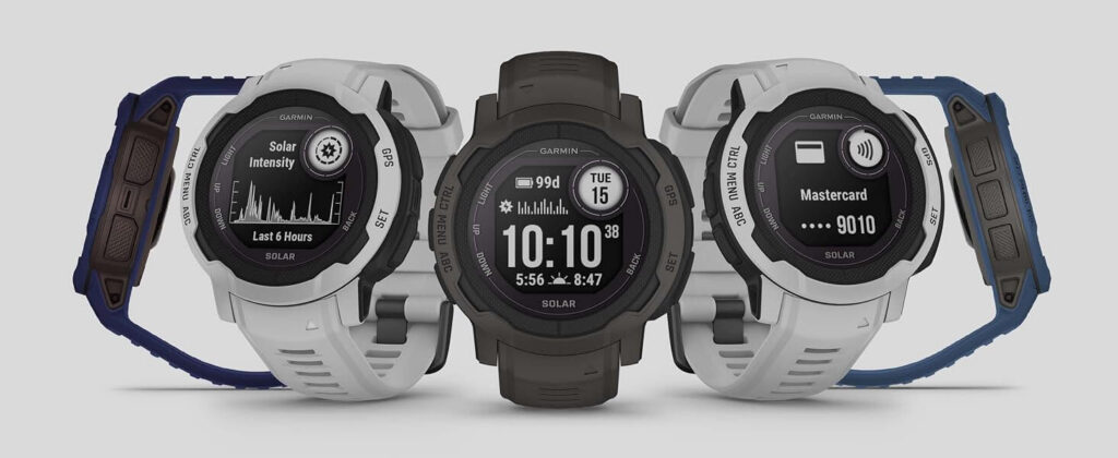
Weight: 52 g (about 1.8 oz) | Battery life: unlimited in smartwatch mode with solar charging; up to 48 hours in GPS mode with continuous solar | Display: 1.27 in, sunlight-readable | GPS: GPS, GLONASS, Galileo | Water resistance: 100 meters | Sensors: 3-axis compass, barometric altimeter, heart rate, Pulse Ox | Best for: Day hikers who want GPS on the wrist with no separate device | Worst for: Hikers who need detailed topographic maps
The Instinct 2 Solar is a watch that happens to have a GPS, and that is the whole design. The GPS runs continuously, the track logs automatically, and the 1.27-inch screen is always on — small enough that you glance once to verify you are on trail, then you are back in the landscape. It carries a 3-axis compass, a barometric altimeter, a heart rate sensor, and a Pulse Ox monitor, so the hiker who wears it has the information needed to confirm a route without stopping to pull out anything else.
Solar charging is the feature that changes the device’s role in the backcountry. In smartwatch mode, with about three hours of direct sunlight per day, battery life becomes unlimited. In GPS mode with continuous sunlight, it runs for up to 48 hours. A multi-week backcountry trip no longer forces the hiker to plan around a dead device.
The watch supports three global satellite systems — GPS, GLONASS, and Galileo — for reliable position across terrain. It is water-rated to 100 meters, thermal-resistant, and shock-resistant, built from a fiber-reinforced polymer case with scratch-resistant Corning Gorilla glass. At 1.57 × 1.57 × 0.52 inches and 52 grams it is lighter than any other device on this list.
The limitation is screen size. At 1.27 inches the Instinct cannot show detailed topographic maps. It is not the device you consult when you are lost. It is the device you consult to confirm you are on the right trail, to see how far you have walked, and to mark a point of interest without breaking stride.
Why it fits: a watch the hiker glances at once and forgets — GPS, elevation, and track all running quietly under the skin of attention the hiker keeps on the trail.
5. Garmin GPSMAP 66i — The Dedicated Navigation Screen
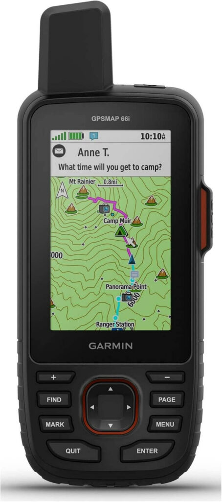
Battery life: up to 16 hours with GPS and satellite communication; up to 35 hours with display off in 10-minute tracking mode | Display: 3 in, sunlight-readable color, 240 × 400 | Connectivity: Iridium (messaging, SOS, weather, Track and Share) | Maps: Preloaded Garmin TOPO mapping with direct-to-device Birdseye satellite imagery downloads (no annual subscription) | Supported GNSS: Multi-GNSS | Sensors: Barometer, compass, altimeter | Best for: Multi-day travelers who need detailed maps and satellite communication in one device | Worst for: Day hikers who do not need detailed maps or a subscription
The GPSMAP 66i is the most capable device on this list, and its price reflects the combination it packs into one rugged unit. A 3-inch sunlight-readable color display shows contour lines, trail names, and waypoint markers at a glance. Preloaded Garmin TOPO maps come with direct-to-device Birdseye satellite imagery downloads that do not require an annual subscription. Two-way satellite messaging, interactive SOS, weather forecasts, and multi-GNSS support all run through the 100 percent global Iridium network.
For the multi-day traveler who genuinely needs a screen — long expeditions in unfamiliar terrain, route-critical crossings, days when intuition alone is not enough — the 66i is not luxury. It is the right tool. Preloaded TopoActive maps and the waypoint manager mean the hiker who marks a point of interest or reviews trip data in the field has the information needed to finish the route.
The discipline the device asks is the same one the guide is about. Used correctly, the 66i is a reference: the hiker confirms their position once, marks a waypoint, and returns to reading the terrain. Used the wrong way — checked every minute — it is not navigation, it is screen-following, and the spatial intelligence the hiker should be building is being eroded.
An active satellite subscription is required for Iridium messaging, SOS, and location sharing, and the cost is listed on the Garmin subscription page. The 35-hour battery in 10-minute tracking mode with the display off covers a long trip without a recharge, and Expedition mode with 30-minute tracking extends it further.
Why it fits: it is the white at its fullest — maps, messages, SOS, all in one rugged device — but it only serves the standard when the hiker keeps it there as a reference and lets the attention return to the land.
The Standard, Applied
The five devices above are ranked by the same standard: does this device know its place — knowing the white, keeping to the black, and never replacing the hiker’s attention with a relationship to a screen?
The Garmin inReach Messenger is the simplest and lightest check-in device on the list. A confirmation screen, three functions, a small monthly subscription. Forgotten until needed.
The Garmin inReach Mini 2 is the safety net for the solo hiker who needs two-way messaging, SOS, and a return path. TracBack draws the way home. Up to 14 days of tracking on a single charge.
The ACR ResQLink view is the most reliable no-subscription emergency beacon. One button, one signal, a global COSPAS-SARSAT network, and no monthly fee.
The Garmin Instinct 2 Solar is GPS on the wrist. Always on, always logging, a glance-and-forget device that runs unlimited in smartwatch mode with solar.
The Garmin GPSMAP 66i is the right tool for the multi-day traveler who genuinely needs a screen — maps, Birdseye imagery, messaging, and SOS in one rugged device, used as a reference, not as the trail.
Whatever you carry, a backcountry GPS device is never the trail. It is the safety net the hiker checks once at the trailhead, forgets about, and thanks when they get home.
Integrating Your GPS Device Into the Whole Gear System
The device that earns its place is the one the hiker does not notice. In The Mindful Roaming Gear System, every piece of gear serves the body quietly and disappears back into the pack. The second skin that manages warmth and the shoes that read the ground are already working in the hiker’s favor. The GPS device is the piece that, when it knows its place, returns the hiker to the terrain in the same moment it has returned the hiker’s confidence.
All specs referenced above are sourced from Amazon at the time of writing. Weights, battery life, display size, and features can vary by model year and region. Check the Amazon product listing for the most current specifications and pricing before you buy.
知其白,守其黑 — know the white, keep to the black. The technology the hiker should know cold: the device that is checked once at the trailhead and then forgotten until the trail end.